 DREAM WULAR
The Wular lake was known as Mahapadamsar in ancient times and in Nilamata Purana it has been referred to as ‘Mahapadmasaras’. The Mughal historian Al-Biruni (960-1031 AD) has called the Wular as ‘Bolor’. Some experts are of the view that word ‘Bolor’ might be corrupted form of Sanskrit word ‘Ullola’, the name by which the lake was also known.
 Share and Like
 VISIT TOP LAKES
There are several lakes in Kashmir that have attracted visitors for ages; Dal Lake, Wular Lake, Nigeen Lake and Manasbal Lake the most popular, among others.

Recent tour packages


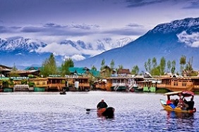

About Wular Lake
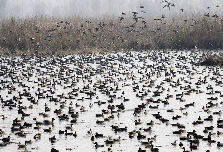
Wular Lake is one of the largest freshwater lakes in Asia. It plays a significant role in the hydrographic system of the Kashmir valley by acting as a huge absorption basin for the annual floodwaters. The lake, along with the extensive marshes surrounding it, is an important natural habitat for wildlife. It is also an important habitat for fish, ac$counting for 60 per cent of the total fish production within the State of Jammu and Kashmir. The lake is a source of livelihood for a large human population living along its fringes. The catchment area of the lake supports magnificent coniferous forests, alpine pastures and orchards, adding to the natural beauty and biodiversity of the wetland area. In recognition of its biological, hydrological and socio-economic values, the lake was included in 1986 as a Wetland of National Importance under the Wetlands Programme of the Ministry of Environment and Forests, Government of India for intensive conservation and management purposes. Subsequently in 1990, it was designated as a Wetland of International Importance under the Ramsar Convention. The lake along with its satellite wetlands, is a suitable wintering site for a number of migratory waterfowl species such as the common teal, pintail, shoveller, common pochard, mallard and others.It is an important habitat for fish and contributes about 60 percent of the fish yield of the Kashmir valley. The lake sustains a number of endangered and endemic species of flora and fauna. The Wular lake is densely populated with different macrophytic species. Three zones of vegetation viz. (i) emergent, (ii) rooted, floating - leaf type and (iii) submergent are distinguishable in the lake. All three zones are characterised by a specific type of life form embracing a distinctive assemblage of plant species. The extent and occurence of individual species is closely related to variations in water depth and its associated influences. A total of 82 species of phytoplankton have been reported in Wular lake fl ora. Overall, 50 species of zooplankton have been reported. The Wular lake is an important habitat for the fish fauna of the region. It provides about 60 per cent of the fish yield of the Kashmir region. The dominant fish species found in the Wular are: Cyprinus carpio, Barbus conchonius, Gambusia affinis, Nemacheilus sp., Crossocheilus latius, Schizothorax curvifrons, S.esocinus, S.planifrons, S.micropogon, S.longipinus and S.niger.
The Wular lake with its characteristic features sustains a rich population of avifauna. Terrestrial birds observed around the lake are the black - eared kite, sparrow hawk, short - toed eagle, Himalayan golden eagle, hawks and vultures, monal pheasant, chukar partridge, kiklas pheasant, blue rock pigeon, cuckoo, small cuckoo, alpine swift, Kashmir roller, Himalayan pied woodpecker, hoopoe, common swallow, golden oriole and others.
Wular Lake, One of the largest fresh water lakes in Asia, is in Bandipora district in the Indian state of Jammu and Kashmir. The lake basin was formed as a result of tectonic activity and is fed by the Jhelum River.
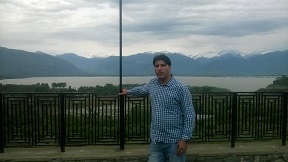
Wular Lake Location
Address: Bandipora, Jammu and Kashmir 193501Surface elevation: 1,580 m Length: 16 km
Inflow source: Jhelum River
Outflow location: Jhelum River
Recognisation
In recognition of its biological, hydrological and socio-economic values, the lake was included in 1986 as a Wetland of National Importance under the Wetlands Programme of the Ministry of Environment and Forests, Government of India for intensive conservation and management purposes. Subsequently in 1990, it was designated as a Wetland of International Importance under the Ramsar Convention
Wular Lake Geography | |
 | |
| Location | Jammu and Kashmir |
| Coordinates | 34°20′N 74°36′ECoordinates: 34°20′N 74°36′E |
| Primary inflows | Jhelum River |
| Primary outflows | Jehlum River |
| Basin countries | Kashmir/(disputed area) |
| Max. length | 16 km |
| Max. width | 9.6[1] km |
| Surface area | 12 to 100 sq mi (30 to 260 km²) |
| Max. depth | 14 metres |
| Surface elevation | 1,580 m |
| Islands | Zainul Lank |
| Settlements | Sopore-Bandipore |